British Columbia, July 4:
This week saw a scorching heat wave in Canada and the United States. Temperatures in Western Canada and the Northwest of the United States reached 50°C, shattering previous highs. Lytton, British Columbia, set a new national temperature record of 49.6°C. The heat wave also caused a wildfire in Lytton, destroying 90% of the village and causing significant damage. The areas with the hottest temperature recorded in North America were Salem, Oregon at 47.23°C and, Portland International Airport at 44.45oC on Sunday and 46.12°C on Monday. The latter broke the temperature records set since the recordings started in 1940.
These regions normally have a very mild climate, and many homes do not need air conditioning. As a result of this the heat wave has exposed thousands of people to the sweltering heat. Many people have been forced to seek shelter in air-conditioned buildings. Heat is more intense in urban areas than in greener, rural areas. The heat has been so intense that power cables have melted, roads and car windows cracked. Schools were closed and public transportation was also halted in some regions.
What is a Heat Wave?
When temperature recordings show that the daily maximum temperature is higher than the average temperature for that place and has continued so for at least 2 days, the temperature is termed as a Heat Wave.
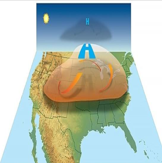
What is causing the heat wave?
Let us try to understand it with an analogy. Imagine a closed pot with air inside, when you heat the pot, the pressure and temperature of the air inside will increase but remain constant as the hot air escapes from the pot. But if you place a lid on the pot and do not allow the hot air to escape, the air inside the pot will continue to heat even faster because there is no place for the hyperactive particles to escape creating extremely hot conditions inside the pot. This is exactly how a Heat dome is created. A body of air is trapped close to the surface and pressed downwards by a high-pressure system working over it. This trapped air heats up and tries to rise, but the high-pressure system above pushes it back downwards and does not allow it to escape. This further increases the heat and pressure of the trapped air creating a heat dome and resulting in a heat wave.

The underlying cause:
The oceans play an important role in Earth’s weather, particularly changes in the Pacific Ocean, the world’s largest and deepest ocean, affects weather all over the world. Under normal circumstances, winds above the Pacific Ocean gently push warm water westward from Americas towards Australia and Indonesia (Picture: Normal Condition). As the warm water moves away, cold water from the ocean’s depths rises to take its place.
El Nino (meaning a small boy in Spanish) is a weather pattern that occurs in the Pacific Ocean every few years. During an El Nino year, the westward winds above the Pacific Ocean become very weak and sometimes blow in the opposite direction (Picture: El Nino Condition). This results in accumulation of warm waters near the American coast. The Pacific jet stream (a current of fast- flowing air high in the Earth’s atmosphere that blows from the Pacific to North America) moves south of its neutral position due to the warmer oceans (picture below). As a result of this shift, places in the northern United States and Canada become dryer and warmer as seen now. But in the US southeast and the Gulf Coast are wetter than usual and can experience increased flooding. This is a natural phenomenon but temperatures recorded this week are unprecedented and raising concerns of extreme climatic change.
