June 17th celebrated as World Day to Combat Desertification and Drought.
New Delhi, June 21: Desertification is the process by which fertile land transforms into a desert. It can be a temporary or permanent decrease in land productivity. Desertification is largely caused by anthropogenic (man-made) factors such as deforestation, mining and improper methods of agriculture. It can also be caused naturally by physical, chemical, or biological factors.
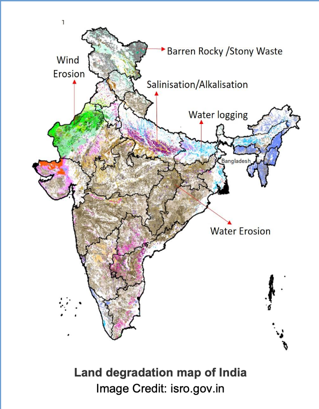
ISRO’s Space Applications Centre (SAC) in Ahmedabad, in collaboration with various national institutes, monitored desertification across the country using data from Indian Remote Sensing Satellites (IRS). They created desertification and drought maps using IRS data and generated information on land degradation at 1:50,000 scale. The maps show the state-by- state area of degraded lands for the fiscal year 2018-19. It also provides a change analysis over a 15-year period, from 2003-04 to 2018-19.

Image Credit: isro.gov.in
The maps and key findings were compiled into an Atlas, which was released on June 17, 2021, in commemoration of the World Day to Combat Desertification and Drought.
Desertification and land degradation are significant threats to agricultural productivity around the world. In an agrarian country like India, updated information on degraded land is critical for the government to plan necessary measures to combat degradation processes and to plan reclamation programmes. This Atlas is now available for policymakers, regional planners, and researchers to use as a quick reference when making mitigation plans to reduce the impact of desertification and land degradation.

The United Nations Convention to Combat Desertification (UNCCD), comprising of 197 countries, was established in 1994 to raise awareness, and promote sustainable land management. The Ministry of Environment, Forests, and Climate Change (MoEF&CC) in India is the nodal agency for interactions with UNCCD.
The UNCCD 2018-2030 Strategic Framework for Sustainable Development intends to achieve Land Degradation Neutrality (LDN) by 2030. LDN refers to the ability to keep the amount and quality of land resources required to support an ecosystem stable or increasing over time. This aims to improve the living conditions of over 1.3 billion people who live in such areas. India is working to meet its national commitments for LDN and the restoration of 26 million hectares of degraded land by 2030.

